Hike & Run DuPont State Forest
Hiking DuPont State Park is a treat for hikers, runners, bikers, waterfall hunters, and horse riders. The trails are well maintained and easily accessible as well as breathtakingly beautiful. If you have time for just one trail in DuPont we suggest Triple, High, and Hooker Falls – three trails in one.
Hooker Falls, Easy
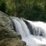
Hooker Falls is a wide 13 foot drop leading into a large pool that is frequented by swimmers in the summer. Around the pool are several large rocks for sun bathing. This fall is beautiful year round. Approaching the fall is a nice overlook for picture taking. Directions: Take 276 to the south out of Brevard for approximately 10 miles of fun winding roads. Turn left onto SR 1536 (Buck Forest Road) just after Grammy’s Restaurant. Turn right onto Station Road (if you hit the gravel road you’ve gone too far). The parking lot for Hooker Falls is on the left just after the bridge. The trail head is at the end of the parking lot at the river. Trail Characteristics: Wide, flat. To get to the base of the falls there is a short hill to traverse (3 flights of stairs).
Triple Falls, Easy to Moderate
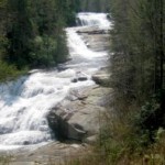
Triple Falls is a series of three tall cascading falls that will take your breath away. I take people on this hike when I want them to understand why I moved to Brevard. The hike is best early in the morning or on a weekday when there are less folks around. Even when the trail is full you can get fantastic pictures so don’t fret. The trail follows the river and is level for a while, it draws you in and let’s you think it’s going to be a cake walk then the trail turns to reveal a steep uphill climb (6 flights of stairs). Thankfully the path is wide so if you need to take breaks you can easily stand to the side. Once you’re at the top of the incline you’ll notice the stairs down to the left (5 flights). The stairs take you to the rock plateau at the second fall. Once finished viewing the wonderful waterfall you can turn around and go back or continue on to High Falls. Directions: Park in the same lot as Hooker Falls. The trail head is on the other side of the road on the opposite side of the river. There are stairs leading out of the parking lot. Cross the bridge then cross the road and look for stairs leading down. Please note – you have to climb over the guardrails. Trail Characteristics: Wide, steep grades, stairs. PLEASE NOTE WARNING SIGNS!
High Falls, Moderate to Difficult
High Falls is accessible from Triple Falls and from Buck Forest. My preference is to continue on from Triple Falls. Once you’re up that big hill at Triple Falls the trail to High Falls is relatively flat by comparison. You’ll notice the trail continues to the left after the stairs to Triple Falls. It’s approximately 3/4 to High Falls. The trail follows the river for a good portion of the walk. It’s interesting to see how calm the water is above Triple Falls. The trail splits and either goes straight or takes a sharp right away from the river. To view the full waterfall take the right. You can hear the fall before you can see it. The trail builders did a fantastic job of providing viewing points for these falls. This is where I turn around and walk back to the car. When you’re looking at the falls you can see a building at the top – this is a covered viewing bridge that is easiest to access from the Buck Forest parking lot. To access High Falls from Buck Forest take the trail to the left before the covered bridge. To view the falls from it’s base you take the trail that goes straight instead of the one that forks to the right. A bit of caution here – this trail ends at the rocks. Many people climb the rocks to the right to get closer. There are signs telling you not to. When the water is high (and unless you’re a local you won’t really know how to judge that) climbing the rocks at the base of High Falls can be very dangerous. It’s best to heed the warning signs.
Dense Lake, Easy
 Dense Lake is an easy hike with a wonderful lake at the end of it. It’s about 2 miles round trip along gravel road. The lake is large enough for kayaking, clear enough for great swimming, and full of lots of little fish for fishing – what more could you ask for? Well, there is also a long dock that has a portion of it covered and there is a picnic shelter as well. Get out there and enjoy! Directions: From the Buck Forest Gap Parking lot take Buck Forest Road across the covered bridge which goes over the top of High Falls and take your first right on the gravel road. After a while take a left on the gravel road that spurs off to the left at a sharp angle. (3 Lake Way). After a few hundred feet take the much smaller trail for Dense Lake to the right (you’ll see the lake).
DuPont Trail Run, 9 Miles, Moderate
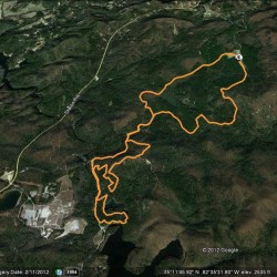 This run has a good mix of fire roads, double and single track – beautiful views of 3 lakes which make it very worthwhile. Directions to Guion Farm parking area from downtown Brevard: From Broad and Main Streets, head down Broad street and pass by Brevard College on your right. As you pass by Ingles and K-Mart also on your right stay right and head forward on Old Hendersonville Hwy. Go through 2 lights and then turn right on Everett Road. At stop sign turn right onto Crab Creek. Follow Crab Creek a couple of miles to a right turn on DuPont Rd. After about a mile turn left at Sky Valley Road. Sky Valley turns to gravel and the parking area will be on your right as you pass a gated Buck Forest Road on your right.
Running Trail Directions: from Guion Farm parking lot off of Sky Valley Rd in dupont. Tarkiln Branch Rd to a left on Thomas Cemetery Rd. Go left on Buck Forest and then left up Chestnut Oak Rd. Turn right on Joanna Rd and then right on Pitch Pine (real nice trail.) Left onto Conservation and left on Three Lakes Trail (beautiful trail!) Follow to Lake Dense and then hook up with a left turn onto Joanna. Go right on Conservation and then turn right on Buck Forest. Go left on Isacc Heath and right on Jim Branch. Left back on to Buck Forest and take to the parking lot. To Download GPS information from Wikiloc, CLICK HERE.
DuPont Trail Run, 9.5 Miles, Moderate
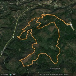 This is a great 9.5 mile loop starting from the Guion Farm parking lot off of Sky Valley Rd. Running Trail Directions: Hickory Mtn. Rd. to Ridgeline. Turn left on Lake Imaging and then left on Jim Branch take right on Isacc Heath and continue on Locust. Turn left on Lake Imaging and left on Buck Forest. Turn right on Thomas Cemetary – cross over Buck Forest and continue on White Pine. Turn left on Hooker Creek. Follow to a right on Ridgeline and then take Hickory Mtn. Rd. back to parking lot. To Download GPS information from Wikiloc, CLICK HERE.
DuPont Trail Run, 14.34 Miles, Moderate
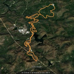 This is a great run that can be added on to or subtracted from depending on your knowledge of DuPont and what your needs are for your training. Invest in a map and take a look at the trails and the directions provided here.
Running Trail Directions: Guion Farm parking lot off of Sky Valley Rd. Take Tarklin Branch Rd to left turn on Thomas Cemetary. Left on Buck Forest and then a right turn on Isacc Heath and then continue forward on to Locust. Cross Lake Imaging Rd. and take Hilltop loop. Go right on Lake Imaging and right on Buck Forest. Left on Conservation and then left on Pitch Pine. Follow past Lake Dense and turn right on Three Lakes Trail before you run “into” Lake Alford. From this end of Three Lakes there is no trail name sign. Just a small sign saying “trail” attached to a tree. Follow Three Lakes to a left back onto Conservation. Go right on Shelter Rock Trail and then turn left on Airstrip Trail. At the top, you will run on the actual airstrip for a short distance and merge right back onto Conservation Rd. Take a right on Scarlet Oak and then head right on Fawn Lake Rd. back to Conservation. At this point you are making your way back to where you began. Follow Conservation and turn right on Joanna Rd. Next turn left on Chestnut Oak Rd. Turn right on Buck Forest and take back to the parking lot. To Download GPS information from Wikiloc, CLICK HERE.


